

Walk
Plan along waymarked trails and real paths, follow the next turn and the climb to come, and record the day from your phone or your wrist.
Details
Offline maps, routes and recording for iPhone, iPad, Apple Watch and Android phones
One app for every way you move outdoors, built for the places the signal doesn’t reach. Plan along real paths and waterways, download the map before you go, then follow and record your route without a signal.
No account. No adverts. No tracking.
Free to download. Pro is optional: by the year, or once for life.

On a computer?
Scan the QR code with your phone’s camera to get the Global Adventurer app.


Activities
Plan along waymarked trails and real paths, follow the next turn and the climb to come, and record the day from your phone or your wrist.
DetailsRecord a run on your iPhone: the route on the map, your time and your pace, saved to Apple Health. Plan the route first and take the map with you.
DetailsRoad, gravel, mountain bike or e-bike. Plan along cycle routes, follow a long-distance ride from the Route Store, and record speed, distance and ascent.
Details
Kayak, canoe or paddleboard. Plan along rivers, lakes and the coast, switch on nautical charts and seamarks, and see tide times for a place on the coast.
Details
Official bathing waters, with the classification each authority gives them, are on the website and in the iPhone app’s swimming layer. Log your swims, or record one on Apple Watch. Android is coming.
See bathing waters
How it works
Tap a destination, or a few points, and the line is drawn along real paths, or along the water for a paddle: on your phone, or in your browser, with distance, ascent and a time before you set off. Follow a waymarked trail, avoid an area, add stops.
Download the area, or just the corridor along your route, before you go. Your position, the map and the route need no signal after that; one area is free, Pro makes it unlimited.
The next turn, the distance left and the climb to come, and a word if you leave the line. One tap records the outing and keeps it in your own iCloud.
Great Britain
Switch the map to Ordnance Survey Outdoor, Road or Light, and plan, follow and record on the national map of Great Britain. It is a layer in the map menu, and it is free.
Contains OS data © Crown copyright and database rights 2026

Offline
GPS positioning does not require mobile reception, so recording and following a saved route work without signal. Maps and new routes do not, unless you fetch them first.
Support has a short before you lose signal checklist.
Apple Watch
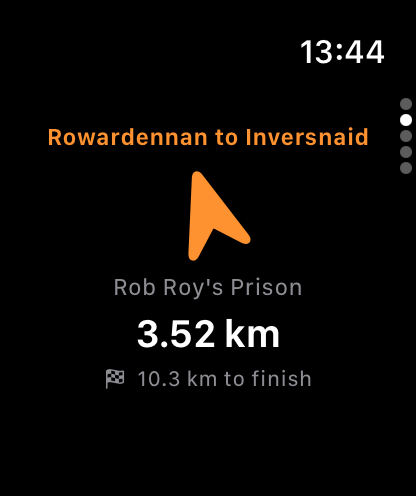
Privacy
Your hikes stay on your devices and in your own iCloud. There is nothing to sign in to, and nothing is collected for advertising or analytics. A few features talk to a server to do their job, such as fetching map tiles, planning a route or getting spoken directions, and the privacy policy lists each one and what it sends.
Free and Pro
Pro is optional, by the year or once for life. In the UK that's £9.99 a year, or £49.99 once for life; elsewhere the App Store shows the price in your currency before you buy.
Groups and outdoor education
The same app prepares a day out for a walking group, a class or an expedition team.

Questions
Recording, because GPS positioning does not require mobile reception. Any map area you downloaded beforehand. Following a saved route, including its spoken directions if they were fetched while you had signal. Your hikes, places and gear, and the Emergency Location screen, which shows your position even when a call cannot be made. Planning new routes, listing trails, searching places, the weather and sharing your position all need a connection.
Walk, ride and paddle: plan along paths, cycle routes or the water, follow the route and record it on iPhone, and on Apple Watch for a walk or a paddle. Run: a run is recorded on iPhone with GPS and pace and saved to Apple Health. Swim: official bathing waters are on the website and in the iPhone app’s swimming layer; the app also keeps a swim log, and an open-water swim can be recorded on iPhone or Apple Watch. Android is coming. On the water, nautical charts for US waters and seamarks worldwide are map layers you can switch on, tide times for a place on the coast are one tap away, and a paddle at sea reads in nautical miles and knots. The planner knows nothing of tides, currents, wind or access rights, so check them before you go. Paddling features.
Yes. Open a GPX file, or another common route file, from Files, Mail, AirDrop or any share sheet and choose Global Adventurer, or use Import Track on the Home screen. Waypoints, notes and symbols are kept. Formats in and out.
In Great Britain. When you follow a route there, the app fetches its junction directions once from our routing server and keeps them with the hike, so they are spoken offline on later walks. Everywhere else there are no junction directions, but the app still speaks when you leave the route and rejoin it, before a steep climb, when you arrive and, if you turn them on, at each kilometre or mile, while the map shows the distance to the next waypoint and the distance left.
iPhone and iPad on iOS or iPadOS 17 or later, and Apple Watch on watchOS 10 or later. The iPad version also runs on Macs with Apple silicon and on Apple Vision Pro. Recording needs a device with GPS; a Wi-Fi-only iPad can plan routes, view hikes and keep them in sync. An Android phone app is on Google Play; features that need the Apple Watch or Siri are for iPhone.
Something not working? The support page has the troubleshooting steps.
Free to download for iPhone, iPad, Apple Watch and Android phones.
No account. No adverts. No tracking.
Every long-distance route in the Route Store is free. Pro includes our own day walks, rides and paddles near you, drawn along the paths and the water.